time travel recognition
6 juli 2006Today I had to go and pick up a package from the Post office (well nowadays it’s inside the supermarket). I thought it was the book on hiking in Sarek I ordered, but so wrong I was!
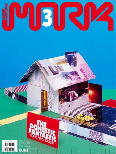
To a great suprise it was a magazine called MARK, which is about architecture etc by the same people who makes FRAME Magazine. First I had no clue why I got it but after looking through it I found a whole spread about my Time travel map!!
This is what they say:
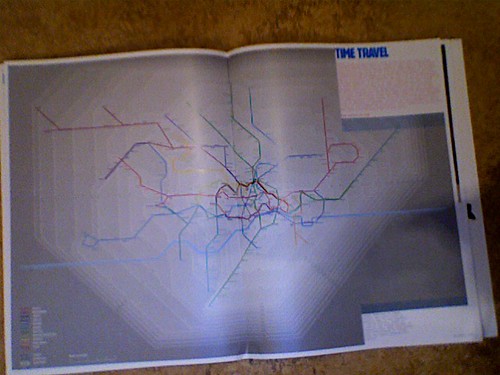
”These days, people don’t talk about how far away they live but about how long it takes to get there. With this realization in mind, Oskar Karlin redesigned the London Underground map as part of a grauation project at the London College of Communication. The London Underground map is a classic 20th-century design, of which a slightly revised version is still in use. Created in the 1930s by Harry Beck, the map does not indicate the distance between stations or the geographical locations of the stations themselves. Karlin’s map combines geographical accuracy with travel times between stations. His diagram of underground lines takes into account trains travelling at different speeds, as well as considerable variations in the number of stations. Tube comuters using his map have a brand-new view of the city.”
When I got home I also noticed that my map is visible on the cover of the magazine too! (look above)
FYI, my project is also mentioned in a dissertation recently by Nicholas Street at Department of Computing, Imperial College London.
Kudos to be recognised in such a smart magazine but did the copy just turn up out of the blue. Didn’t they ask for permission before using your copyright work. After all some might say its derogatory treatment to cut the map up and use it as the wall of a house. In this Internet age, its good to share, but its also good to talk and ask.
/Barbara Cookson 2006-07-07, 16:18
I think they sent me an email many months ago and I had completely forgotten it, but I love it! I mean, I really like when people use my work in any way. All my photos on flickr are on Creative commons license, too.
/oskar 2006-07-14, 14:42
Hi Oskar,
Glad you liked the article. We’re the authors of the ”Mapping the urban landscape” article – it’s been a couple of months ago that you sent us the map, but it takes quite some time from the conception to be on the shelfs (for a magazine like that). We arranged for a copy to be sent to you, we thought you would like that :)
best,
Auke Touwslager – http://www.informationlab.org
Ursula Lavrencic – http://www.megla.org
/Auke 2006-07-16, 10:46